Thursday, July 28, 2011

LOST MISSION EXPEDITION APRIL, 2011: In search of Santa Isabel

PART 1 (Friday April 29)
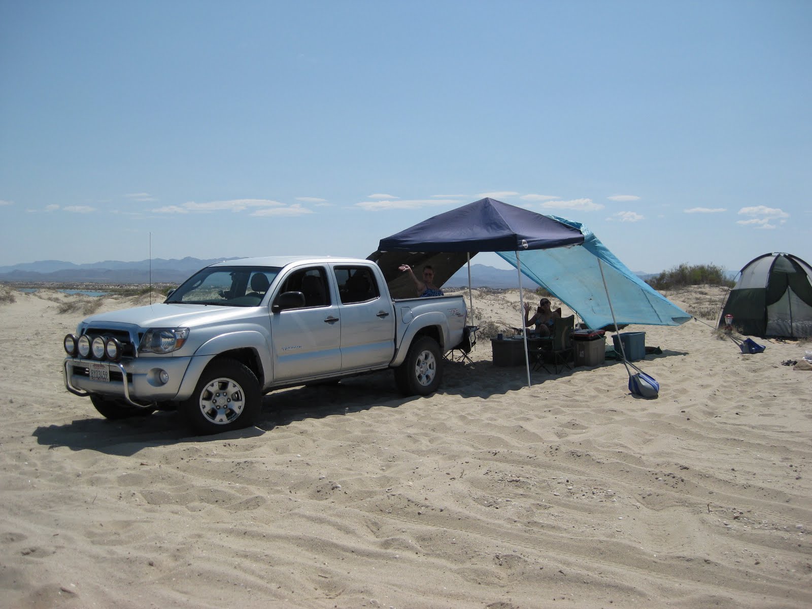
My fellow adventure seeker was Baja Nomad member ‘El Vergel’ (Vern) from the Los Angeles area and the beach campo south of San Felipe. ‘Baja Cat’ (José) who waited for us just across the border at Otay Mesa joined and traveled along with us on Friday.

The drive south was easy and fun.

http://i213.photobucket.com/albums/cc212/DavidKier/EL%20VOLCAN%202011/Volcan007.jpg
Corredor 2000 zips you around Tijuana to or from Otay or Tecate (Vern Pic)


We stopped for lunch in San Vicente at a taco cart operated by Gloria, who served us ‘tacos de borrego’ (lamb tacos) along with a cup of consommé de borrego to which we added onions and salsa… YUM


Vern 'El Vergel'


José 'Baja Cat'


We arrived in El Rosario about 2:30 to fill our gas tanks and buy a few cases of Tecate and Dos Equis cerveza. I also wanted to show Vern the rooms at Baja Cactus Motel as they are so outstanding given the location and typical highway accommodations usually found in Baja. We also saw Itzel’s mother who reported her daughter as doing fantastic following the heart surgery of several months ago.


Baja Cactus Pemex (Vern Pic)

http://i213.photobucket.com/albums/cc212/DavidKier/EL%20VOLCAN%202011/Volcan069.jpg
Baja Cactus Motel front desk (Vern Pic)

http://i213.photobucket.com/albums/cc212/DavidKier/EL%20VOLCAN%202011/Volcan071.jpg
Hugo Lopez art at Baja Cactus (Vern Pic)

http://i213.photobucket.com/albums/cc212/DavidKier/EL%20VOLCAN%202011/Volcan074.jpg
Baja Cactus room (Vern Pic)

Fuel prices in Baja (below the border region) were 8.77 pesos per liter for Magna and 9.87 for Premium. The exchange rate at Baja Cactus was 11.20 pesos per dollar and in Ensenada on Sunday was 11.00 pesos per dollar… both close to $3.00 per gallon.

The 56 mile drive down Highway One to the El Marmol road was a breeze and the signed road was between the 148 and 149 kilometer markers. The next 9 miles to El Marmol are dirt, but some of the easiest dirt miles in Baja and would be a breeze for most vehicles.

We stopped to take new photographs of the schoolhouse ruins and cemetery before the final leg of today’s drive down to Arroyo el Volcan. I heard the sound of a speeding Toyota Tacoma and it was ‘TW’ (Tom) and his brother Bill arriving from an ice run to Cataviña (20 miles distant). José, Vern and I followed them down to the campsite in Arroyo El Volcan, 4 miles from El Marmol.


Already there was ‘bajalou’, ‘dtbushpilot’ (David) and ‘XRPhlang’ (Phil) on the sand/gravel arroyo at the base of a giant rock face. That evening was plenty fun discussing just why the hell we all drove hundreds of miles and spent hundreds of dollars to be in such a place! It was great!


'bajalou' and 'BAJACAT'


'XRPhlang' (Phil) and 'dtbushpilot' (David)


'El Vergel' (Vern), Bill W and 'TW' (Tom)

http://i213.photobucket.com/albums/cc212/DavidKier/EL%20VOLCAN%202011/Volcan2011035.jpg


TW made a batch of grits to supplement our morning diet and we secured camp for the day's hike. It looked on the map to be about 3-4 miles down the arroyo to the primary site of elbeau's Santa Isabel (arches, stairways, fountains). I called the location 'site B' on my Google Earth map. Our camp was just a few hundred feet down the wash from the El Marmol-La Olvidada mine road (which was totally graded very recently).

The last photo posted above in Part 1 was the morning showing our camp.

Our camp was in the arroyo, on the left of this image:

http://i213.photobucket.com/albums/cc212/DavidKier/Maps/El%20Marmol/campsites.jpg

The site (white tag 'site B') was exactly a 4 mile hike away:

http://i213.photobucket.com/albums/cc212/DavidKier/Maps/El%20Marmol/StaIsabelhike.jpg

We begin the hike:

http://i213.photobucket.com/albums/cc212/DavidKier/EL%20VOLCAN%202011/Volcan2011037.jpg

The arroyo of El Volcan was extremely interesting and is well worth the visit (even without a lost mission)! I will let my photos do most of the story telling...

http://i213.photobucket.com/albums/cc212/DavidKier/EL%20VOLCAN%202011/Volcan2011038.jpg

http://i213.photobucket.com/albums/cc212/DavidKier/EL%20VOLCAN%202011/Volcan2011039.jpg

Water in small amounts was near our camp and oozing out of a cliff at the first big bend.

http://i213.photobucket.com/albums/cc212/DavidKier/EL%20VOLCAN%202011/Volcan2011040.jpg

http://i213.photobucket.com/albums/cc212/DavidKier/EL%20VOLCAN%202011/Volcan2011042.jpg

http://i213.photobucket.com/albums/cc212/DavidKier/EL%20VOLCAN%202011/Volcan2011044.jpg
David K, always happy to be in Baja!

http://i213.photobucket.com/albums/cc212/DavidKier/EL%20VOLCAN%202011/Volcan2011045.jpg

http://i213.photobucket.com/albums/cc212/DavidKier/EL%20VOLCAN%202011/Volcan2011046.jpg

http://i213.photobucket.com/albums/cc212/DavidKier/EL%20VOLCAN%202011/Volcan2011047.jpg

http://i213.photobucket.com/albums/cc212/DavidKier/EL%20VOLCAN%202011/Volcan2011048.jpg
A piece of onyx trapped in newer rock, along the arroyo.

http://i213.photobucket.com/albums/cc212/DavidKier/EL%20VOLCAN%202011/Volcan2011049.jpg

http://i213.photobucket.com/albums/cc212/DavidKier/EL%20VOLCAN%202011/Volcan2011051.jpg

http://i213.photobucket.com/albums/cc212/DavidKier/EL%20VOLCAN%202011/Volcan2011052.jpg

http://i213.photobucket.com/albums/cc212/DavidKier/EL%20VOLCAN%202011/Volcan2011053.jpg

http://i213.photobucket.com/albums/cc212/DavidKier/EL%20VOLCAN%202011/Volcan2011054.jpg

http://i213.photobucket.com/albums/cc212/DavidKier/EL%20VOLCAN%202011/Volcan2011055.jpg

Where I left off in Part 1 was near the end of the 4 mile hike down Arroyo El Volcan... As we looked high up the cliffs to the location of the corral in elbeau's satellite images we could not see directly the level or semi-level area. It was out-of-sight, and some of us wished to find a way up there for a closer look... Now, if we only had a helicopter, like Erle Stanley Gardner did 40 some years ago!

bajalou had all the sites GPSed on his hand-held and I had the primary Santa Isabel site on mine... That was my goal: to get right to the spot that elbeau saw 'man-made' structures like arches, stairways, fountains, etc. If that was there, then we would look for the others places later.

On the Google Earth image, the site is just off the main arroyo, along a side gully...


http://i213.photobucket.com/albums/cc212/DavidKier/Maps/El%20Marmol/StaIsabelsouth.jpg


http://i213.photobucket.com/albums/cc212/DavidKier/Maps/El%20Marmol/301421144629.jpg

Both images are looking southwest, up the side gully...

GPS of the site marked by the white ballon: GPS is 30º01.42', -114º46.29' (WGS84). Elevation is 1,701'

Here are the views as we near the final big S bend in the arroyo, see the corral area, and see the entrance to the LOST MISSION side gully (maybe call it Arroyo Santa Isabel?):


http://i213.photobucket.com/albums/cc212/DavidKier/EL%20VOLCAN%202011/Volcan2011056.jpg

http://i213.photobucket.com/albums/cc212/DavidKier/EL%20VOLCAN%202011/Volcan2011057.jpg

http://i213.photobucket.com/albums/cc212/DavidKier/EL%20VOLCAN%202011/Volcan2011058.jpg

http://i213.photobucket.com/albums/cc212/DavidKier/EL%20VOLCAN%202011/Volcan2011059.jpg
Interesting trench erosion up and over the ridge... Santa Isabel is on the other side!

Wednesday, July 27, 2011

July 4th Weekend, Shell Island to Gonzaga Bay to El Rosario

Our daughter Kristi joined us for a 4 day Baja weekend. We had planned to spend 2 full days on Shell Island then go to El Rosario via Gonzaga Bay to show Kristi more of Baja and check the progress of the new highway construction, south of Puertecitos.

As things turned out, we had a fantastic first day (Saturday), but Saturday night severe winds whipped us and wrecked our sun canopy and tent. The result is we packed up and headed south a day early. The same wind capsized and sunk a fishing ship, the 'Erik', near Gonzaga Bay. We didn't hear of the tragedy until 2 days later on the news.

Saturday afternoon, Art and Nora in their new 4WD motor home arrived near our camp, but across the lagoon as the high tide covered the road onto the island. The next morning, they walked over the empty lagoon (low tide) and shared with us some delicious lumpias and ox tail soup! We all left the same time Sunday morning and headed south.

In El Rosario, we booked a room at the Baja Cactus Motel and had two very restful nights there before coming home. On Monday, we showed Kristi some of the sites around El Rosario and on Tuesday, we took a lunch break at the oak grove 3.8 miles west of Hwy. 1 in the Santo Tomas valley. This was the site of the first mission of Santo Tomas (1791), before it was moved after 3 years.

 Shell Island camp
 North end of the island
 Looking at Baja from the island

 Looking south, down the island
 The access road covered by high tide (it is an island!)
 Art and Nora

 The Enchanted Islands, just after the big storm
 Highway 5 construction, 30 miles south of Puertecitos
 Kristi at Gonzaga Bay
 Elizabeth and Kristi
 Elizabeth is my love.
 Boojum trees on Hwy. 5 near Cocos Corner
 Sun setting Baja cactus scene, Km. 105 on Hwy. 1
 The second El Rosario mission site from 1802
 The Punta Baja lighthouse
 Punta Baja panga launch area near lighthouse
 Driving down La Bocana Beach to the north end
 Lunch break on the beach
 Interesting cliff erosion
 La Lobera (Km. 47.5) sea lion crater


 Baja Cactus Motel, El Rosario


 Oak Grove Campground, Santo Tomas Valley
First site of the Santo Tomas mission, 1791, next to oak grove 3.8 miles west of Hwy. 1 off the Puerto Santo Tomas road (turn left at mile 3.5).
=========================================================================
SAN FELIPE TO LAGUNA CHAPALA:

The following road log was made on the July 4th weekend, 2011.

MILE / KM. Marker

0.0 San Felipe (Traffic Circle by Pemex stations, south turn)

0.8 Pemex station and market on south side of town

6.0 Left Turn off Airport Road, Km. 0
-----------------------------------------------------------------------------------------
(add 6.0 miles to following for distance from traffic circle)

The next 45 miles are well paved, but many short, steep and unmarked dips will require reduced speed to avoid damage.

0.0 / Km. 0 Airport Road/ Puertecitos Road Jcn.

12.5 / Km. 20-21 Rancho Percebu Road

15.7 / Km. 26+ Shell Island Road

18.6 / Km. 31 Bahia Santa Maria Road

19.3 / Km. 32+ Nuevo Mazatlan Road

21.5 / Km. 35.5 Colonia Delicias (markets/ restaurants)

29.6 / Km. 49 El Coloradito Road

32.8 / Km. 54 Campo Cristina Road

35.4 / Km. 58.5 Los Olivos Road

36.1 / Km. 60 Arroyo Matomi

36.3 Rancho San Rafael (well)

43.4 / Km. 72 Playa Destiny

44.9 / Km. 74+ PUERTECITOS (paved) Road
---------------------------------------------------------------------------------------
The newest paved additions to Hwy. 5 are well engineered, wide and are designed and signed for high speed. However, frequent rock slides onto pavement require caution.

0.0 / Km. 74+ Puertecitos Road

5.0 / Km. 83 Bahia Cristina

6.1 / Km. 84.5 La Costilla

7.2 mine road

16.4 El Huerfanito Road

18.9 Bridge at previous end of pavement (July 2010)

20.1 / Km. 311 Change of Km. markers, distance from Mexicali

23.6 / Km. 317

24.1 / Km. 318 END OF PAVED DRIVE, detour onto older road, regraded smooth. Pavement ends just ahead on new roadbed.

25.5 Okie Landing site.

32.0 END OF NEW ROAD CONSTRUCTION and end of smooth dirt detour on older road.

32.4 Campo Delfines Road

35.6 Las Encantadas Road

37.7 Punta Bufeo Road

42.4 Papa Fernandez' Road, roadbed south of here is better/ faster.

43.6 Miltary Checkpoint

45.0 GONZAGA BAY PEMEX/ ALFONSINA'S ROAD/ RANCHO GRANDE MARKET (Pemex closed from 2-4 pm for siesta)
---------------------------------------------------------------------------------------

0.0 Gonzaga Bay Pemex

1.2 Campo Beluga (2.0 mi.) and El Sacrificio (4.2 mi.) Road

7.1 Las Palmitas Oasis (4.7 mi.) and Santa Maria Canyon (4.0 mi.) Road, right.

14.4 First Boojum Trees on Hwy. 5.

14.6 La Turquesa Canyon Road, right.

18.4 Las Arrastras (site) Road, right.

22.1 Coco's Corner (Puerto Calamajue and Mision Calamajue road left).

34.8 Hwy. 1, Laguna Chapala (Cataviña is 33 miles north).